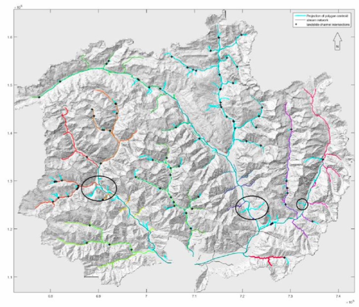
Map of the catchment area or Lake Maggiore (base map derived from a LiDAR greyscale hillshade DEM) which shows the river channels (marked with colours) and the intersections with landslides (marked with black crosses). The black circles mark areas where the intersection would project to the alluvium.
Candidate: Andrina Vlasek
Supervisors: Kerry Leith, Andrea Manconi
Institution: ETH zurich
Activity: Completed summer 2016
Natural hazards such as landslides happen frequently in Switzerland, more than 6% of Switzerland’s area is prone to slope instability. Not all landscapes are equally prone to landslide instabilities, but depend on various factors, such as geologic (e.g. lithology), topographic (e.g. slope steepness) or climatic factors (e.g. length and intensity of rain- falls), which are common to large areas. The aim of this study project is to analyse the distribution of large deep seated gravitational slope deformations (DSGSD) and a possible relationship to river incision. This will be examined in the southern part of the Swiss Alps; more precisely the catchment area of the Lake Maggiore, which consists of a fluvially formed, western part, a central and eastern region which was more glacially shaped. DSGSDs are a widespread phenomenon in mountainous regions. There is a positive correlation of the degree of valley incision and the abundance of DSGSDs. As most valleys in the catchment area of Lake Maggiore are fluvially incised nowadays, especially in the western region, this further increases the susceptibility of large slope instabilities. To investigate this subject, the landslides were mapped using a combination of Google Earth and QGIS in order to produce a categorised distribution map. The data from this map then could provide input data for an analysis of the association of landslides with river channels. After a selection to only analyse the large deep-seated landslides, the final data was processed in Matlab. The result displays intersections of landslides with river channels, excluding the alluvium. The distribution of the landslides and channel intersections show that they are somewhat clustered in the western, fluvially formed part. In this region at 700m above the alluvium often a knickpoint could be detected. Further up, this knickpoints are followed by a flatter part which displays less landslides. The assumption can be made that there are less landslides on flatter terrains because the erosional force and therefore the incision is weaker there. This supports the thesis that the landslide distribution is positively correlated with river incision.
Recent Comments