Hi all,
Over the last few years I’ve spent a lot of time working in the Alps – learning about the valley geomorphology, slope instabilities, bedrock properties… enjoying the steep valleys, long trails, alternately hot and freezing weather, and supermarkets closed at lunchtime.

A German version of steep valleys and freezing weather;
A view from the top of the inaccessible (for this scientist) north wall of the Zugspitze this Feb.
At the same time I’ve become reliant on web-based GIS as a means of maintaining field data, using tools such as Google Earth to keep it accessible even when I wasn’t in the office – or when the office was not as ordered as it should have been. As I begun to generate modelling data, the simple format, and flexibility of .kml (the .xml?-based language of GE) lent itself to quickly producing results out of a number of softwares…
The ability to compare field data to model results in a 3-D GIS environment, and share and discuss results with colleagues around the world without requiring any special software, provided some of the greatest insights during my time in Zurich.
I now have a reasonably large library of code, tools, and .kml-based geo data that grew with the project, but never really reached a ‘mature’ stage… Over the next months I hope to begin outlining some of the methods and tools I found most useful… and while I’m not an html-monkey I’ll try to present some of the ideas, concepts, useful websites, and codes using the awesome google .api library.
To start, I’ve linked the 1:500 000 geological maps of Switzerland, (Liechtenstein), and Germany as Google Earth and Google Maps overlays on my “Online maps” page. In the next days I’ll describe where to find the data, how to adapt it, and some of the benefits of having something like this available in a 3-D open source platform!
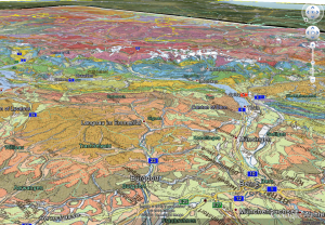
3D Geology of the Swiss alps looking out over Thun, Tichino, and south toward Italy
Recent Comments