Recently, my co-authors and I published a rather controversial article entitled ‘Signatures of Late Pleistocene fluvial incision in an Alpine landscape‘ in Earth and Planetary Science Letters (Volume 483, Leith et al., 2018). In this post we summarise the main outcomes, and look into a part of the backstory that never made it to print.
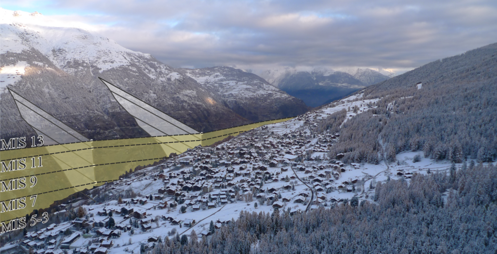
Illustration of modeled prehistoric river channels and projected hillslopes for the end of significant interglacials at Marine Isotope Stages 13 – 3. The photo is taken looking north from the village of Graechen in the Matter Valley, Switzerland.
The great debate
At the turn of last century two of Europe’s pre-eminent Earth scientists were embroiled in a long-running debate regarding the processes involved in shaping the European Alps. Albert Heim (1849 – 1937) was a Swiss geologist who served as a professor of technical and general geology at ETH Zurich (1872 – 1875), before moving to a professorship at the nearby University of Zurich (1875 – 1911), and Albrecht Penck (1858 – 1945) was a German geologist and geographer who, after a short stint teaching at the University of Munich, became a professor at the University of Vienna in 1885, before moving to Berlin as professor of geography in 1906. While Heim may be regarded as a more traditional geologist, publishing on topics ranging from the mechanics of mountain building, to landslide dynamics, and phenomena associated with glaciation, Penck was very much interested in the manner in which surface processes (e.g. rivers, glaciers, and landslides) shape the landscape. Penck spent much time studying the geomorphology (a term he is attributed to coining in 1894) of glaciations, and outlined four major Pleistocene ice ages based on sediments distributed on the broad planes surrounding the European Alps.
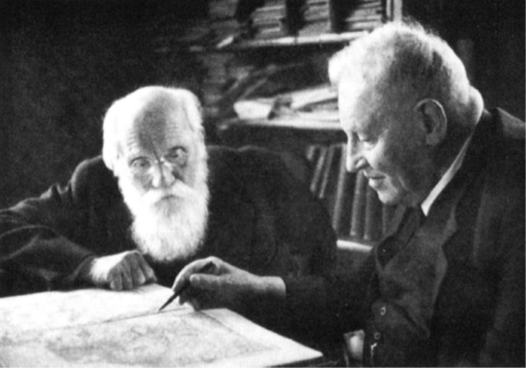
Albert Heim (left) with Albrecht Penck (right) (in Brockmann et al. 1952).
Though I don’t pretend to be a historian, the relationship between Heim and Penck seems to have been a complex one. In ‘Albert Heim: Leben und Forschung’, Brockmann et al. (1952) describe a great friendship between the two scientists, while their writings relating to the origin of the Alpine landscape (a topic which must have been close to each of their hearts) are quite combative. In Heim’s 1885 ‘Handbuch der Gletscherkunde’, he discusses the relative roles of glacial and fluvial erosion in the formation of large Alpine valleys:
‘The only question is which of the two agents, ice or water, applies the greatest erosional strength to the mountain, or in other words which has the higher efficiency? The decision is not difficult: compared to the effects of water:
a) The ice consumes a larger proportion of it’s energy to overcome its internal deformation, to flow. The water very little.
b) The effect of ice is spread across a large wide area. The river is focused on a narrow path.
c) The ice spends energy crushing fine particles, sanding, and polishing the rocks for which a high pressure is required; the river works at a larger scale, it is to some extent a coarser file, a rougher grindstone, it doesn’t polish or scratch, but works by impacting debris,
d) The presence of ice means that external mechanical, and in a narrower sense chemical weathering agents are excluded from the erosion process, it must do everything itself; the flowing water employs the help of many weathering agents.‘
Original textp 388 – 389: Die Masse der erodierenden Substanz und ihr Gefälle , soweit sie auf dem Boden läuft , sind das Mass für die innewohnende Erosionskraft. Ob je nach den klimatischen Verhältnissen die Niederschläge als Eisstrom oder als Wasser zu Thale gehen, ändert die Arbeitsmenge nicht, welche von der Sonne durch Hebung in sie gelegt worden ist und nun erodierend wirksam wird. Sie hat ein bestimmtes Mass. Es fragt sich nur , welches von beiden Agentien, Eis oder Wasser ihre Erosionskraft geschickter auf die Ge- birgsmasse anwendet, so dass ein höherer Nutzeffekt entsteht, Da ist denn der Entscheid nicht schwierig:
a) Das Eis verbraucht einen bedeutenden Teil von Arbeit zur Ueberwindung seiner Kohäsion, zum Fliessen, das Wasser nur sehr wenig, b) Das Eis verteilt seine Wirkung auf eine grosse breite Fläche; der Fluss konzentriert sie auf einen schmalen Weg. e) Das Eis zehrt einen Teil seiner Arbeitskraft in feinster Zermalmung, Zerschleifung und Politur der Gesteine auf, wozu Arbeit mit hohem Druck erforderlich ist ; der Bach arbeitet im grobem , er ist gewissermassen eine gröbere Feile, ein rauherer Schleifstein, er poliert und ritzt nicht , sondern schlägt nur die Trümmer zusammen, d) Das Eis schliesst die Mithilfe der mechanischen, teilweise sogar der chemischen Verwitterung im engem Sinne des Wortes grösstenteils aus, es will alles selbst machen ; das fliessende Wasser benutzt die Verwitterung zu reichlicher Mitarbeit.
He goes on to say:
‘Glaciers may have produced some morphologies inconsistent with erosion by fast rivers, but in the overall formation of the mountain landscape the effect of glaciers lags far behind. Glaciation therefore likely causes a relative stillstand in valley formation.
This view contains no hypotheses, it is not based on deductions, it is rather a result of direct and observable facts. I consider these to be binding.’*
Original textp. 389 Damit ist selbtverständlich nicht gesagt, dass dem Gletscher nicht gewisse Resultate möglich sind, die das Wildwasser nicht zustande bringt, aber wohl, dass in der gesamten Masse der thalbildenden Wirkung der Gletscher notwendig weit hinter dem fliessenden Wasser zurücksteht, und dass Vergletscherung relativem Stillstand in der Thalbildung gleichkommt.
Diese Betrachtung enthält keine Hypothesen, sie baut nicht auf Deduktionen auf, sie ist vielmehr eine Erwägung der direkt vorhandenen und beobachtbaren Thatsachen. Ich halte sie deshalb für massgebend(*emphasis is mine)
These observations, and perhaps more importantly clear deductions based on what many would say are ‘modern’ principals of energy and geomorphic work are strong arguments for a fluvial (river driven) origin for major Alpine valleys. Contrary to Heim’s statement, however, none of these observations would pass the bar of scientific ‘fact’ today, as (amazingly) systematic studies testing the efficiency of one process against the other are lacking in the literature.
Perhaps that’s because the opinions of the younger Penck were very firmly planted on the other side of the fence. In 1905 Penck published a paper in the Journal of Geology entitled ‘Glacial Features in the Surface of the Alps‘, in which he concludes:
‘The actual surface features of the Alps do not at all correspond to those of a water-worn mountain range. Their conformation is mostly due to ice-action, which becomes most visible where the old glaciation ceased.’
It’s quite unusual for an article nominatively discussing ‘glacial features’ to make such a bold statement against an alternative origin (this should require a study (or more) of itself), and is almost certainly an attack on the opinions of Heim and others by the new Berlin professor. Penned largely as an opinion piece in (what is now at least) one of the most influential geological journals, the article constantly alludes to what must have been a vibrant argument at the time, rallying around the personal observations of glacial features by Penck and his colleagues during his time in Vienna.
Paris and Grenoble at war
Around the time of Heim’s retirement, the debate was reignited in the ‘Battle of the Alps‘ between two former students of the great Parisian geographer Paul Vidal de La Blache (as reported in a 2001 article by N. Broc). Emmanuel de Martonne (1873-1955) was a ‘cold’, ‘distant’, and ‘gruff’ provincial bourgeoisie, who first married de La Blache’s daughter, before replacing him as the Head of Geography at the University of Paris in 1909. From a simple background, Raoul Blanchard (1877-1965) was slightly younger than de Martonne, and the complete opposite in character. Charismatic, fearless, and adored by students, on completion of his PhD in Paris Blanchard was appointed to the University of Grenoble in 1905, and rapidly gained a devoted group of disciples. There started a battle that would span two world wars, and settle in what seems to have been an exhausted truce around 1945. As in the conflict between Penck and Heim, the younger, charismatic (Grenoble) geographer seeking to make a name for himself favored a glacial origin for the Alpine landscape, while the elder (Parisian) statesman correlated features observed in the field with the operation of fluvial processes. Here, it’s important to know that de Martonne worked under Penck in Vienna from 1895 – 1899, and in Broc’s (2001) article, he openly wonders if the position taken by de Martonne is ‘..the influence of certain German and Austrian geographers reacting against their predecessors?‘.
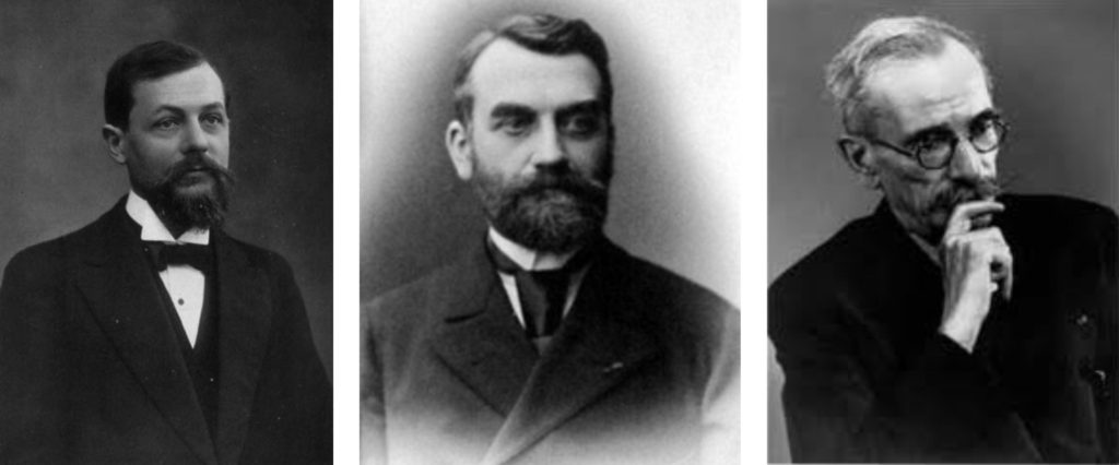
de Martonne (left) favoured a fluvial origin and assumed the Head of Department role in Paris. Vidal de la Blache (center), the former Head of Department who had previously worked under Penck, and supervised the PhD’s of both men. And Blanchard (right) the glacial proponent from Grenoble.
In the colorful debate, Blanchard, commenting on one of his first student’s publications stated:
this young geomorphologist (Blache, 1914) ‘victoriously refuted the theories’ of E. de Martonne on evolution of alpine valleys ‘Demonstrating that stepped tiers on Belledonne’s flanks were glacial erosion levels’, he asserted that ‘none could belong to an ancient Pliocene valley bottom (that is to say, anterior to glaciations)‘. And Blanchchard, who was never modest in triumph, concluded: ‘So this boy of twenty years has seen more than the head of French physical geography!’ (referring to de Martonne, who at the time was 20 years his senior).
Original textp. 97 – 98: Bientôt, paraissent les premiers travaux de Jules Blache, l’un des plus anciens disciples de Blanchard. Dans un mémoire sur le Grésivaudan publié en 19145, ce jeune géomorphologue « réfutait victorieusement les théories d’E. de Martonne sur l’évolution des vallées alpestres. Démontrant que les gradins étages sur les flancs de Belledonne étaient des niveaux d’érosion glaciaire, il affirmait implicitement « qu’aucun ne pouvait appartenir à un ancien fond de vallée pliocène » (c’est-à-dire antérieur aux glaciations). Et Blanchard, qui n’a pas le triomphe modeste, de conclure: «Ainsi ce gamin de vingt ans avait vu plus juste que le chef de la géographie physique française ! Paul Veyret fixe avec raison à 1914 et à l’article de Blache la date de naissance de l’École de Grenoble.
The first world war interrupted proceedings, and one can assume the discussion immediately faded to the background. In 1926 André Cholley’s thesis emerged from Paris as a direct challenge to the school of Grenoble. In this, the 40 year old geographer (who Blanchard irreverently terms a ‘young man‘) identified more than six levels of erosion between 350 and 1400 m a.s.l., attributing them wholly to the effects of interglacial fluvial incision (this is essentially our “new” result). Blanchard, in commentary to a latter work championing repeated cycles of glacial erosion by his student (Blache, 1931), pondered ‘Can we suspect the existence of old erosional surfaces? No trace … ‘ and in reference to Cholley’s thesis ‘to negate the hypotheses ventured: even before demonstrating inanity, we feel that they are useless.’. Of course the suggestion of remnant valley floors did not occur entirely in isolation, and workers such as Gygax (1934) and Machatschek and Staub (1927) came to similar conclusions in other regions of the Swiss Alps. However, to my knowledge, only Gerber (1959) perpetuated the idea beyond the second world war.
A lingering haze
Jump forward more than half a century, and our manuscript proposing a strong fluvial overprint on extremely old glacial landforms in the Swiss Alps was described a reviewer as ‘a significant departure from conventional wisdom‘, while another commented
‘… it strains credulity to think that delicate features such as fluvial knickpoints* could survive being overridden by ice with little to no modification‘.
*nb. ‘knickpoints’ are essentially smoothed waterfalls for geomorphologists
There has not yet been a study to quantify the degree of erosion of an alpine landscape through a single glacial cycle (at least in the last half-million years), and without going into too much detail, the paradigm that erosion during ice ages is the key driver of topographic change in the Alps is now so ingrained in the scientific literature that our proposition of what is essentially a very old idea was regarded by one reviewer as a ‘provocative, potentially revolutionary (if correct) analysis‘.
Recently, a number of studies have made significant steps to clear the haze. Korup et al. (2007) reasoned that deep gorges close to main trunk valleys in the Alps had to be older than the current glacial, while in a 2015 article, Matt Fox, myself, and a co-authors used erosion rate estimates to demonstrate that fluvial gorge formation in a catchment on the southern side of the Alps outpaced glacial erosion at the same location for the last ~400 kyr. However, without good reason to attribute a large amount of erosion to one glacial cycle, and little to others, the paradigm of a primarily glacial origin continues to dominate scientific literature.
Updating the state-of-the-art
In two earlier studies, my co-authors and I found that fractures growing in bedrock below Alpine glaciers during a particularly strong shift to glacial conditions (known as the Mid-Pleistocene Transition (MPT), around 780 kyr ago) may have developed in a somewhat explosive manner, literally popping rock off the glacier bed as the massive alpine glaciers thinned (See this post for a video of similar fractures forming in California recently). While glaciers are certainly important conveyors of fractured rock, we suggested the energy for fracturing, and therefore degree of erosion, was derived from elastic stresses in the rock itself. Modelling subsequent glacial cycles indicated the return to glacial conditions then confined and stabilized the deep valleys, preventing erosion during subsequent glacial cycles. The Alps have been through nine major glacial cycles with a period of approximately 100 kyr since the MPT, and although some sedimentary evidence indicates the first cycle likely caused the most erosion, the common assumption that Alpine valleys are the result of cumulative glacial erosion has (at least in the last 70 years) prevented researchers looking further into the fluvial history of the region.
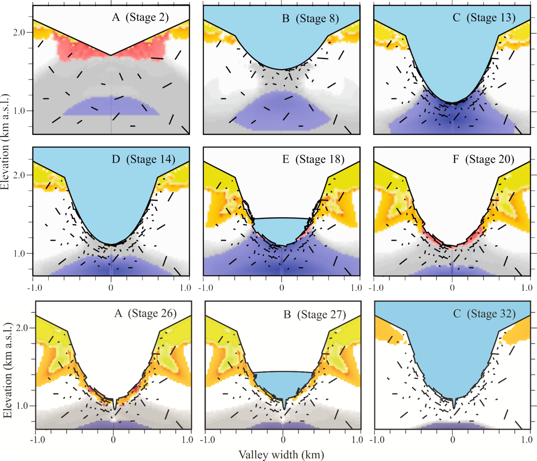
Predicted distribution of various types of fracture beneath an Alpine valley. Here we start with a ‘V’ shaped topography, introduce ice, and manually cut out the center of the valley. Fractures forming in tension and shear are colored yellow and orange, respectively, while active ‘micro-cracking’ is purple, and regions in which we predict explosive fracturing are marked in red under the ice. Note how the area of explosive fracturing increases as we remove ice, and the difference in fracture distribution between model Stages 14 and 32, for which the only difference is the relief of stresses during the intermediate period of deglaciation (Leith et al. 2014a, b).
Our recent study
Spurred on by our previous results, and recent advances in the evaluation of longitudinal river profiles (see Perron and Royden, 2012), we decided to test whether the geomorphology of major tributary valleys in the central Swiss Alps reflected that of a fluvial system. Controversially, we adopted the deductions of Heim, updated with what we now know regarding energetic fracturing in exhuming bedrock, and assumed a strong period of glacial erosion and overdeepening at the MPT, followed by climate cycles in which no erosion occurs at the valley axis during glacial periods. We first searched for attributes of the present-day river channels consistent with that of a normal fluvial system (i.e. a reduction in gradient with increasing catchment area, downstream elevations that approach the present-day Rhone Valley, and a population of similar knickpoints across multiple catchments). The first two observations were reasonably easy to confirm using standard GIS tools (thanks to efficient and open-source QGIS), while the latter required us to undertake a recently developed ‘chi’ analysis that allows us to scale the river morphology by stream power (strong rivers generally erode faster). We found that both the elevation, and upstream location of around 80% of identified knickpoints were consistent with our concept of a fluvial origin, lining up nicely with where they should be expected given the timing of glacial – interglacial transitions derived from MIS curves. As knickpoints erode, they also propagate upstream with time, and the oldest are are now located approximately half-way into each valley; beyond which exists what we term a ‘relict glacial landscape’ that has essentially been uplifted and covered / uncovered by ice with minor erosion over the last 780 kyr. We found that predicted uplift rates are within 15% of present-day measurements, while erosional efficiency for each catchment is reasonably consistent across the region (as expected, given the similar bedrock and rainfall patterns).
This was good news. We then decided to take parameters from the ‘chi’ analysis and run forward models to see if we could reproduce the river profiles with our assumed history. It’s one thing to locate a few (70) steepened sections on an undulating channel profile, it’s something else to reproduce the form of 100 km of combined river channels using the same assumptions. But that’s what we did, reproducing the channel profiles with a mean residual elevation error of just 26.3 m. Given the 400 – 700 m of relief between the Rhone Valley and the uppermost knickpoint in each catchment (this depends on the degree of initial glacial overdeepening), the error is remarkably good. We found our calculated erosion rates are exactly in line with what should be expected for river channels and retreating knickpoints in an alpine setting. The animation below demonstrates two of the larger catchments in our study area developing since MIS 12 and 10, respectively.
Some valleys were initially carved out far below the level of lakes surrounding the Alps, and therefore spent much time filled with sediment (in fact many valleys today remain in this state). However, as if a giant were rising from a bath tub, subsequent tectonic uplift has continually raised the bedrock mountains, while water draining off continually washes sediment out of the valleys, maintaining terrace surfaces that smoothly transition onto to the relatively stable foreland. As evident in our above model of channel evolution, the results allow us to assess the elevation of the channel at any stage since bedrock on the valley floor was exposed. This is a deliberately simple model, and doesn’t include complicating factors such as isostatic rebound (the effect of removing the mass of glaciers from the mountains), landslides entering the channels, movement on tectonic faults, or even the manner in which rivers erode bedrock. However, natural systems are complicated, and constantly changing, making it difficult to define a start point from which to begin studying these phenomena (the end of the last glacial around 18 ka is typically assumed to be a reasonably significant ‘reset’). In fact, no-one really understands any of these effects, and all are topics of rapid advance with popular debate among Earth scientists. Results from our study could allow scientists to stretch the observation window by almost 50x (to 780 ka), while discrepancies between what we model and what we see in the field are useful targets to start looking at the effects of different phenomena on the formation of river valleys.
We demonstrate an example of the insights that may be gained from our channel evolution model by picking three cross-sections where the mountainsides adjacent to the rivers appear relatively stable. Assuming that the rock slopes evolve toward a consistent slope angle determined by long-term rock strength (a concept known as ‘strength equilibrium’), we project the modeled channel elevation at the end of each interglacial from the center of the valley up to the flanks of the mountains. At this time we find modeled incision rates are lowest, and might expect rates of landsliding around the rivers to be similarly low, as relatively long planar slopes separate the retreating landslide front from the active river channel. We find that upper hillslopes consistently project toward our initial (upper) channel profile, while hillslope breaks at our selected cross section locations are reasonably consistently picked up by the projected stable river elevations, suggesting a very old landscape may be preserved at higher elevations, while lower slopes are controlled by retreating waves of landslide formation. The correlation of model results and hillslope profiles at three locations in the study region is summarized in the figure below.
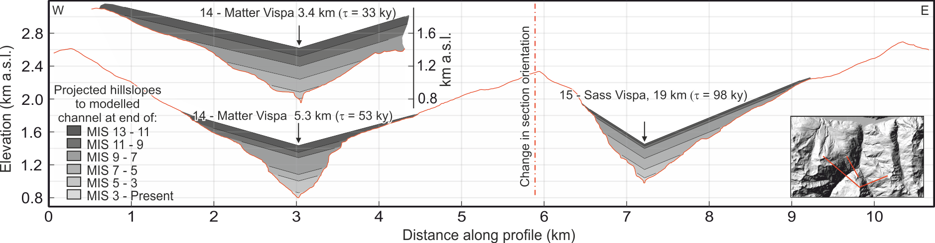
Projected stable hillslopes from modeled end-of-interglacial channel elevations.
A comparison with glacial erosion models
Of course it’s natural to compare our results with what one reviewer described as the ‘wide body of literature‘ addressing the potential effects of glacial erosion on the Alps. In fact, the hypothesis that glaciers drive erosion in Alpine regions is so broadly accepted that important institutions such as the Swiss National Cooperative for the Disposal of Radioactive Waste (NAGRA) commendably spend significant resources investigating the phenomena (five reports have been commissioned to date NAB 09-23, NAB 10-34, NAB 10-18, NAB 10-33, NAB 12-48), while studies addressing fluvial erosion in this region are almost non-existent (I believe NAGRA, for example, is yet to address this issue). To allay readers concerns, we looked closely at the the predicted distribution of glacial erosion in the same region as described in two recent studies (Sternai et al., 2013, and Heman et al., 2011), comparing this to our own results. The erosion predicted by the two models varies widely, with the model of Herman et al. (2011) predicting around 1000 m more erosion than equivalent locations and time intervals in Sternai et al. (2013). However, when we look at the upper ‘relict glacial’ reaches determined for each catchment in our study region, we see that given the right selection of parameters, both models are likely to be doing a reasonable job at predicting the distribution of erosion in the region. Our fluvial models do a very good job reproducing the river profiles in the ‘fluvial’ section of the landscape. these observations led us to incorporate a figure illustrating the ‘best of both worlds’, with adjusted glacial model results upstream (for the die-hard fans), and our fluvial model results downstream. This analysis can help us better understand where and when the glacial models are working, and (incorporating results from fracture models discussed above) may help better parameterize the calculation of overdeepening in the future.

Upper: Modelled stages of fluvial incision. Lower: A ‘best of both worlds’ compilation of numerical model results for three valleys in our study region. Black lines indicate the present-day profiles of the Rhone valley and three tributaries. S0 (adjusted) and L0 refers to the modelled present-day elevation of the valley axis determined from glacial (Sternai et al. 2013) and fluvial models (Leith et al. 2018). Grey lines represent the downstream projection of the modeled glacial profiles into what we regard as the fluvial portion of the landscape.
Conclusions
Our results show that the European Alps are in the middle of a long transformation, from an early post-glacial landscape back to a more stable sub-aerial system. Our findings provide first insight into long-term (~0.7 My) erosion rates in this region, and strongly suggest that deglaciation leads to a marked increase in sediment production as a result of rapid river incision and increased landslide activity. Insights derived from this study will allow practitioners to better assess the response of alpine landscapes to climatic fluctuations (critical for geohazard evaluation and planning for nuclear waste storage), and may open the door to a wide range of research into long-term mechanical, biological, and chemical systems within similar environments.
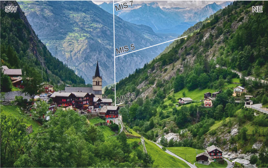
Looking north from the village of Eisten in the Saas Valley, the bedrock river channel takes a significant dive downstream at the location of our MIS 3 to present knickpoint (bracketing the Last Glacial Maximum).
References:
Blache, J., 1914. Le bord d’auge glaciaire du Grésivaudan (rive gauche), Recueil des travaux de /’Institut de Géographie alpine, 353-406
Blache, J., 1931. Les massifs de la Chartreuse et du· Vercors
Broc, N., 2001. Ecole de Grenoble contre école de Paris : les Alpes enjeu scientifique. Revue de Géographie Alpine, 95-105.
Brockmann-Jerosch, M., 1952. Albert Heim : Leben und Forschung. Basel : Wepf.
Cholley, A., 1925. Les Préalpes de Savoie (Genevois, Bauges) et leur avant-pays. Étude de géographie régionale
Fox, M., Leith, K., Bodin, T., Balco, G., Shuster, D.L., 2015. Rate of fluvial incision in the Central Alps constrained through joint inversion of detrital 10Be and thermochronometric data. Earth and Planetary Science Letters 411, 27-36.
Gerber, E., 1959. Form und Bildung alpiner Talböden. 14, 117-236.
Gygax, F., 1934. Beitrag zur Morphologie der Valle Verzasca. Schweizer Geograph 11, 168-187.
Heim, A., 1885. Handbuch der Gletscherkunde. Verlag von J. Engelhorn, Stuttgart.
Herman, F., Beaud, F., Champagnac, J.-D., Lemieux, J.-M., Sternai, P., 2011. Glacial hydrology and erosion patterns: A mechanism for carving glacial valleys. Earth and Planetary Science Letters 310, 498-508.
Korup, O., Schlunegger, F., 2007. Bedrock landsliding, river incision, and transience of geomorphic hillslope-channel coupling: Evidence from inner gorges in the Swiss Alps. J. Geophys. Res. 112.
Leith, K., Fox, M., Moore, J.R., 2018. Signatures of Late Pleistocene fluvial incision in an Alpine landscape. Earth and Planetary Science Letters 483, 13-28.
Leith, K., Moore, J.R., Amann, F., Loew, S., 2014a. In situ stress control on micro-crack generation and macroscopic extensional fracture in exhuming bedrock. J. Geophys. Res. 119, 594–615.
Leith, K., Moore, J.R., Amann, F., Loew, S., 2014b. Sub-glacial extensional fracture development and implications for Alpine valley evolution. J. Geophys. Res. 119, 62-81.
Machatschek, F., Staub, W., 1927. Morphologische Untersuchungen im Wallis. Eclogae Geologicae Helvetiae 20, 335-379.
Penck, A., 1905. Glacial Features in the Surface of the Alps. The Journal of Geology 13, 1-19.
Penck, A., Brückner, E., 1909. Die Alpen im Eiszeitalter, Leipzig.
Perron, J.T., Royden, L., 2012. An integral approach to bedrock river profile analysis. Earth Surface Processes and Landforms, n/a-n/a.
Sternai, P., Herman, F., Valla, P.G., Champagnac, J.-D., 2013. Spatial and temporal variations of glacial erosion in the Rhône valley (Swiss Alps): Insights from numerical modeling. Earth and Planetary Science Letters 368, 119-131.
Recent Comments